

Agriculture in the Classroom
Agriculture is an important part of everyone’s life. Clothing, food, fuel, housing, medicine, and much more are rooted in agriculture. Educators across the country are effectively integrating agriculture into the curriculum. Agriculture has no subject matter boundaries and can become a part of social studies, language arts, science, math, environmental education, art, music, or in a combination of areas that effectively integrate key agricultural principles.
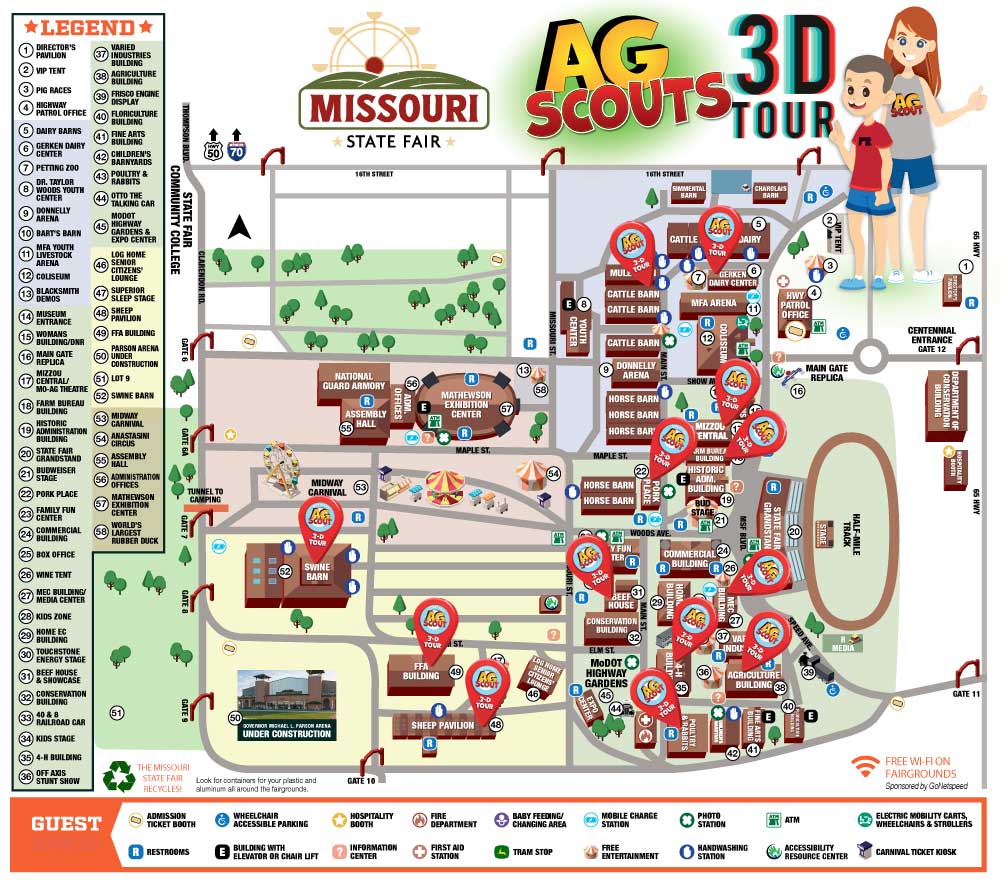
2025 Missouri State Fair Ag Scouts 3D Tour
Check out the map below to track the Ag Scouts throughout the 2025 Missouri State Fairgrounds!
Agriculture in the Classroom Mini-Grant Program
$12,000 awarded annually
Missouri Farm Bureau Foundation for Agriculture is offering competitive mini-grants of up to $500 for use in Missouri classroom programs K-12 that promote agricultural literacy. The budget section of the application provides space for detailing the amount needed and how it will be utilized.
Click here to access the scholarship application.
County Check-Out Program
MOFB loans out educational items for counties and members for the purpose of promoting agriculture. Items include a large wooden cow, whiteboard, puzzle table and grain bin display.
Access the checkout form online.
From the Farm: Virtual Field Trips
Created to help continue the promotion of agriculture in Missouri classrooms during the COVID-19 pandemic, Missouri Farm Bureau developed a series titled “From the Farm: Virtual Field Trips.” This series of informational videos is perfect for Grade 4 through Grade 6 students but can be used in any classroom – virtual or in-person.
Visit our YouTube page to watch all 14 episodes!
Farm Safety
Farms and ranches are great places to work, as long as you’re doing it safely! Download our safety handbook or contact us to get paper copies.
Curriculum
Curriculum Matrix
The National Agricultural Literacy Curriculum Matrix is an online, searchable, and standards-based curriculum map for K-12 teachers. Lessons from the Missouri Agriculture in the Classroom are included in this matrix, along with curriculum from other states.
Growing Nation
Middle School and High School teachers: check out this timeline of agriculture complete with a searchable database! This is a great resource for agriculture and social studies teachers.
Resource Catalog
Looking for resources to assist in sharing the message of agriculture? A variety of resource items are available for purchase to use in local efforts.
Visit the Log Home
The Missouri Farm Bureau log home tells the story of history and agriculture through historic artifacts, displays, and short videos describing agricultural life for inhabitants of a young state. Field trips and private tours can be scheduled.
My American Farm is a place for young learners to explore and discover our food, fiber and energy.
Free Farm Game! Feed the World from the Palm of Your Hand.
Journey 2050 takes students on a virtual farm simulation that explores world food sustainability.